Silistra Province
43°55′N 27°10′E / 43.917°N 27.167°E
Silistra Province
Област Силистра | |
|---|---|
 City of Silistra on the Danube River | |
 Location of in Bulgaria | |
| Country | Bulgaria |
| Capital | Silistra |
| Municipalities | 7 |
| Area | |
• Total | 2,846.3 km2 (1,099.0 sq mi) |
| Population | |
• Total | 97,770 |
| • Density | 34/km2 (89/sq mi) |
| Time zone | UTC+2 (EET) |
| • Summer (DST) | UTC+3 (EEST) |
| License plate | CC |
| Website | www |
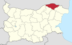
Silistra Province (Bulgarian: Област Силистра, Oblast Silistra) is a province of Bulgaria. Formerly known as the Silistra okrug, it is located on the northeast corner of Bulgaria. The province is part of the Southern Dobrudja region, with its largest and major city being Silistra. As of 2021, the province had a population of 97,770 inhabitants, making it the second least populated in the country. It is divided into seven municipalities for administrative purposes.
History
[edit]During the reign of the Roman Empire in the first century BCE, the province was the location of the Roman fortress of Durostorum, and a major river port on the Danube river.[4] In the 3rd century, it was subject of multiple attacks by the Goths.[5] The Slavs invaded and captured the region in the 6th century.[6] During the late Middle Ages, it was part of the conflict between the Ottoman and Russian Empires.[7] It was occupied by Romania before the First World War in 1913.[7] It was part of the Southern Dobrudja region of Romania till 1940, when it became part of Bulgaria.[8]
Geography
[edit]Silistra is one of the 28 province of Bulgaria. [9][10] It was formerly known as the Silistra okrug.[11] It shares borders with the provinces of Dobrich, Shumen, Razgard, and Rousse, and an international border with Romania.[7]
The province is situated on the eastern end of the Danube river plains. The river is used for navigation, and irrigation purposes. It has a continental climate with hot dry summers and cool winters. The Srebarna Lake in the province is a national reserve and a UNESCO World Heritage Site.[6][7]
Sub-divisions
[edit]The province is divided into seven municipalities–Alfatar, Dulovo, Glavinitsa, Kaynardzha Municipality, Silistra, Sitovo, and Tutrakan. The largest is the municipality of Silistra.[3]
|
| |||||||||||||||||||||||||||||||||
| Source: Bulgarian National Statistical Institute[2] | ||||||||||||||||||||||||||||||||||
| Municipality | Cyrillic | Population[2][3] | Largest town |
|---|---|---|---|
| Alfatar | Алфатар | 3,324 | Alfatar |
| Glavinitsa | Главиница | 12,610 | Glavinitsa |
| Dulovo | Дулово | 28,860 | Dulovo |
| Kaynardzha | Кайнарджа | 5,250 | Kaynardzha |
| Silistra | Силистра | 54,885 | Silistra |
| Sitovo | Ситово | 5,810 | Sitovo |
| Tutrakan | Тутракан | 16,920 | Tutrakan |
Demographics
[edit]As of 2021, the province had a population of 97,770 inhabitants, making it the second least populated in the country.[3] The population consisted of 45,648 males and 49,091 females. About 12,497 inhabitants were below the age of fourteen. About 55.5% of the population was rural, while the rest were classified as urban. Bulgarians formed the major ethnic group with 56% of the population, and Turks formed a significant minority with 37.4% of the population.[3] Romani people constituted about 5.2% of the inhabitants. Christianity had 45,638 adherents (54.3%), followed by Islam at 35,767 adherents (42.6%).[3]
Economy
[edit]The soil is fertile and rich in humus, and conducive to agriculture. About 50% of the land is arable, and major crops include cereals, vegetables and apricots. The Danube river is used for fishing.[7] Major industries include machine tools, electronics, woodworking, textiles, and food processing.[7]
Infrastructure
[edit]The region is well connected with more than 500 km (310 mi) of roads, with major roads connecting to the neighboring provinces. There is a road border crossing with the neighboring Romania. There is a small civilian airfield at Silistra. All settlements in the province have the supply of electricity. There is a teacher training institute apart from the schools imparting education at various levels. Medical services are provided by a regional and several district hospitals.[7]
See also
[edit]References
[edit]- ^ "Bulgarian Provinces area and population 1999" (PDF). National Center for Regional Developmen. pp. 90–91. Archived from the original (PDF) on 13 January 2011.
- ^ a b c "Bulgaria divisions". Bulgarian National Statistical Institute. Retrieved 1 June 2024.
- ^ a b c d e f "Silistra Province". Citypopulation.de. Retrieved 1 June 2024.
- ^ "Durostorum". Livius. Retrieved 1 June 2024.
- ^ Rumen Ivanov; Georgi Atanasov; Peti Donevski (2006). History of Silistra : Ancient Durostorum. Ivrai Publishing House. p. 93.
- ^ a b "Bulgaria celebrates its cultural heritage". European Union. 7 August 2017. Retrieved 1 June 2024.
- ^ a b c d e f g "Region portrait". European Union. Retrieved 1 June 2024.
- ^ "Rumania Agrees to Include the Towns of Silistra and Balcic in Cession". The New york Times. 18 August 1940. Retrieved 1 June 2024.
- ^ "Bulgaria divisions". Citypopulation.de. Retrieved 1 June 2024.
- ^ "Bulgarian provinces and municipalities in 2009". Bulgarian National Statistical Institute. Retrieved 1 June 2010.
- ^ "Bulgaria – Government Structure". Country Studies. Retrieved 15 October 2017.


