
Mottram in Longdendale
| Mottram in Longdendale | |
|---|---|
.jpg) Market Place, Mottram | |
 Mottram in Longdendale Location within Greater Manchester | |
| OS grid reference | SJ992956 |
| Metropolitan borough | |
| Metropolitan county | |
| Region | |
| Country | England |
| Sovereign state | United Kingdom |
| Post town | HYDE |
| Postcode district | SK14 |
| Dialling code | 01457 |
| Police | Greater Manchester |
| Fire | Greater Manchester |
| Ambulance | North West |
| UK Parliament | |
Mottram in Longdendale or Mottram is a village in Tameside, Greater Manchester, England. It lies 1 mile (1.6 km) west of Hadfield and 3 miles (4.8 km) east of Hyde. It lies within the historic county boundaries of Cheshire, and became part of Greater Manchester in 1974. Mottram in Longdendale was an ancient parish, which covered an extensive area of north-east Cheshire until it was split into smaller parishes in the 19th century. Mottram lies in Longdendale, the valley of the River Etherow, and is close to the border with Derbyshire.
History
[edit]In 1795, John Aikin described Mottram as follows:[1][2]
Mottram is situated twelve miles from Manchester and seven from Stockport, on a high eminence one mile to the west of the Mersey, from which river the ground begins to rise; half the way being so steep as to make it difficult of access. It forms a long street well paved both in the town and to some distance on the roads. It contains 127 houses, which are for the most part built of a thick flag stone, and covered with a thick, heavy slate, of nearly the same quality, no other covering being able to endure the strong blasts of wind which occasionally occur. Of late, many of the houses in the skirts of the town are built with brick. About fifty years ago, the houses were few in number, and principally situated on top of the hill, adjoining the churchyard, where is an ancient cross, and at a small distance the parsonage house, now gone much to decay and occupied by working people. It is only of late years that the town has had any considerable increase, which has been chiefly at the bottom of the hill, but some latterly on the top...
— John Aikin, A Description of the Country from thirty to forty miles round Manchester (1795)
In the 18th century the River Etherow was known as the Mersey. The River Tame has been a border from the earliest times between the Anglo-Saxon kingdoms of Northumbria and Mercia.[3] The ancient parish was the most northerly in Cheshire.[3]
Mottram came to prominence as a transport hub. It lies on two pack horse routes used to carry salt from Cheshire to South Yorkshire over the Pennines and carry lime for soil improvement from Chapel-en-le-Frith.[4] It was on the stagecoach route between Manchester and Sheffield. Before the Industrial Revolution, Mottram and Ashton-under-Lyne had been the most significant towns in the area. The manor and manorial court house were in Mottram, but other towns eclipsed Mottram in size and importance. Mottram was active in the early stages of industrialisation, and there were significant cotton spinning mills in Wedneshough Green and the Treacle Street areas of Mottram Moor, and printing and dyeing works on the Etherow at Broadbottom which until recently was part of the parish.[4]
_Feb_2008.jpg)
The smaller early mills in Mottram became uneconomic and harder to run. Stalling industrialisation led to social conflict and hunger during 1812 Luddite riots that led to the smashing of labour-reducing machines. The Luddites secretly drilled on Wedneshough Green. In 1842 local Chartists met on the green, and planned the closure of Stalybridge factories in the Plug Riots. By 1860 the population had peaked.[4]
The Sheffield, Ashton-under-Lyne and Manchester Railway was built in the early 1840s, passing along Longdendale. Broadbottom railway station opened in 1842; it was in the township of Mottram, but at the foot of the hill, a mile south of the village centre. The station was called 'Mottram' between 1845 and 1884, then 'Mottram and Broadbottom' between 1884 and 1954, after which it reverted to just 'Broadbottom'.[5]
A Polish pilot, Josef Gawkowski, was killed on 19 July 1942 when his aircraft crashed near Mottram on a training flight from RAF Newton in Nottinghamshire. A memorial plaque commemorating him is in Mottram Cemetery.
Governance
[edit]There is one main tier of local government covering Mottram, at metropolitan borough level: Tameside Metropolitan Borough Council. The council is a member of the Greater Manchester Combined Authority, which is led by the directly-elected Mayor of Greater Manchester. Mottram forms part of the Longdendale ward of Tameside.[6]
Administrative history
[edit]
Mottram in Longdendale was an ancient parish within the Macclesfield Hundred of Cheshire. The parish was subdivided into eight townships: Godley, Hattersley, Hollingworth, Matley, Newton, Stayley, Tintwistle, and a Mottram township which covered the area around the village itself and Broadbottom to the south.[7][8] From the 17th century onwards, parishes were gradually given various civil functions under the poor laws, in addition to their original ecclesiastical functions. In some cases, including Mottram in Longdendale, the civil functions were exercised by each township separately rather than the parish as a whole. In 1866, the legal definition of 'parish' was changed to be the areas used for administering the poor laws, and so the townships also became separate civil parishes.[9]
A Mottram in Longdendale local government district was established in 1873, just covering the Mottram township, administered by an elected local board.[10] Such districts were converted into urban districts under the Local Government Act 1894.[11]
Mottram in Longdendale Urban District was abolished in 1936 to become part of the new Longdendale Urban District.[12][13] In 1931 (the last census before the abolition of the urban district), Mottram in Longdendale had a population of 2,636.[14] Longdendale Urban District was in turn abolished in 1974 under the Local Government Act 1972. The area became part of the Metropolitan Borough of Tameside in Greater Manchester.[15]
Geography
[edit]
Mottram occupies an elevated site straddling the A57 trunk road from the end of the M67 to the junction with the A628 trunk road. It is 10 miles (16 km) east of Manchester, on land between 150m to 250m above mean sea level. The geology is mainly boulder clay above millstone grit,[16] but there are small outcrops of coal at the edge of the Lancashire Coalfield. To the south and east of Mottram is the River Etherow and to the west is the Hurstclough Brook.
Mottram is classed as part of the built-up area of Hadfield (the main part of which is in Derbyshire) by the Office for National Statistics.[17] The Ordnance Survey labels the village 'Mottram in Longdendale' on its maps, but the Royal Mail uses the shorter form 'Mottram' for the postal locality, which is part of the Hyde post town.[18]
Longdendale bypass proposal
[edit]
The A628 trunk road connects the M67 motorway from Manchester to the M1 motorway in South Yorkshire. The road is single-carriageway through Mottram, Hollingworth and Tintwistle and through the Peak District National Park, it is used by large numbers of heavy goods vehicles. It is one of the most congested A-road routes in the country, with high volumes of traffic (including HGVs) using a road which is totally unsuitable for the volume and nature of traffic it carries[19] The A628 through Mottram carries traffic from the A57 road linking Manchester through Glossop to Sheffield over the Snake Pass, another major Trans-Pennine route. Congestion at peak times backs up through Glossop and Hadfield rendering local journeys impossible. To solve these problems the Longdendale Bypass was approved in December 2014,[20] but has not yet been started. There is considerable local feeling that there is no viable alternative to a bypass.[21]
Landmarks
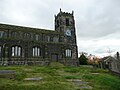
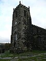
[edit]St Michael and All Angels Church dates from the late 15th century. The church is a Grade II* Listed Building, built in the Perpendicular Gothic style. The interior of St. Michael's was remodelled in 1854 but the exterior remains intact from the 15th and 16th centuries.[22] The church stands high up on Warhill overlooking the village. In 2010, vandals destroyed the church's windows which led to cork boards being used as replacements.
Mottram Old Hall is a country house in Old Hall Lane which dates to 1727 and was once occupied by the Hollingworth family.
-
-
-
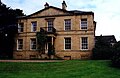 Mottram Old Hall


Sport
[edit]Mottram Cricket Club plays in the Greater Manchester Cricket League. The club was founded in 1860.
Notable people
[edit]- Sir Edmund Shaa was a goldsmith, and Lord Mayor of London in 1482, dying there 20 April 1488. He appeared as a character in William Shakespeare's play Richard III, and a bequest was used to found Stockport Grammar School.
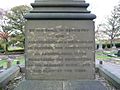
- Lawrence Earnshaw (c.1707–12 May 1767) was an inventor and machine-maker, who made an astronomical clock, and a machine to spin and reel cotton in one operation.[23][24]
-
 Earnshaw Memorial
 -
-


- John Chapman (1810–1877) was MP for Grimsby, High Sheriff of Cheshire, JP and Chairman of the Manchester, Sheffield and Lincolnshire Railway. He lived in Broadbottom.
- The Stretford-born artist L.S. Lowry lived in Mottram from 1948 until his death in 1976. A bronze statue of him seated on a bench is located next to the junction of Hyde Road and Stalybridge Road, and there is a commemorative plaque on his former home, "The Elms" on Stalybridge Road.
-
 L.S. Lowry Memorial
 -
 Lowry's former home, The Elms
 -
 Lowry's Blue Plaque


Famous former residents also include Kathy Staff (aka Nora Batty from the sitcom Last of the Summer Wine) and Harold Shipman, the UK's most prolific serial killer.
See also
[edit]References
[edit]- ^ Aikin, John (1795). A Description of the Country from thirty to forty miles round Manchester. London: John Stockdale. p. 458. Retrieved 18 February 2025.
- ^ Oliver, G.J (2008). "Tameside-Mottram history". Tameside Family Histories. Retrieved 28 October 2011.
- ^ a b Oliver, G.J (2008). "Tameside-Historic Boundaries". Tameside Family Histories. Retrieved 28 October 2011.
- ^ a b c "Township Information - Mottram-in-Longdendale". TamesideMBC. 25 May 2011. Retrieved 28 October 2011.
- ^ "Index of Railway Stations" (PDF). Cheshire Archives. p. 5. Retrieved 18 February 2025.
- ^ "Election Maps". Ordnance Survey. Retrieved 2 February 2025.
- ^ "Mottram Ancient Parish / Civil Parish". A Vision of Britain through Time. GB Historical GIS / University of Portsmouth. Retrieved 14 February 2025.
- ^ Book of Reference to the Plan of the Parish of Mottram-in-Longdendale. Ordnance Survey. 1874. Retrieved 14 February 2025.
- ^ Youngs, Frederic (1991). Guide to the Local Administrative Units of England: Volume II, Northern England. London: Royal Historical Society. p. xv. ISBN 0861931270.
- ^ "No. 23970". The London Gazette. 25 April 1873. p. 2087.
- ^ Kelly's Directory of Cheshire. 1914. p. 476. Retrieved 17 February 2025.
- ^ "Mottram in Longendale [sic] Urban District". A Vision of Britain through Time. GB Historical GIS / University of Portsmouth. Retrieved 18 February 2025.
- ^ "Ashton under Lyne Registration District". UKBMD. Retrieved 19 November 2024.
- ^ "Population statistics Mottram CP/AP through time". A Vision of Britain through Time. Retrieved 18 February 2025.
- ^ "Local Government Act 1972: Schedule 1", legislation.gov.uk, The National Archives, 1972 c. 70 (sch. 1), retrieved 15 January 2025
- ^ "6. Geology of Tameside". Contaminated Land Strategy. TamesideMBC. 28 February 2011. Retrieved 28 October 2011.
- ^ "Towns and cities, characteristics of built-up areas, England and Wales: Census 2021". Census 2021. Office for National Statistics. Retrieved 8 August 2023.
- ^ "Find an address". Royal Mail. Retrieved 18 February 2025. (Search for SK14 6JJ for examples of official postal addresses in Mottram.)
- ^ "Introduction". Longdendale Siege Committee website. Archived from the original on 9 January 2008. Retrieved 20 January 2008.
- ^ "Mottram Bypass Finally Approved". Real Deal website. 9 December 2014. Retrieved 15 December 2014.
- ^ "Suggested Alternative Solutions?". Longdendale Siege Committee website. Archived from the original on 20 August 2008. Retrieved 20 January 2008.
- ^ Nevell, Mike (1991). Tameside 1066–1700. Tameside Metropolitan Borough and University of Manchester Archaeological Unit. pp. 122, 140. ISBN 1-871324-02-5.
- ^ *Lawrence Earnshaw-Manchester2002 Website[usurped]
- ^ *Lawrence Earnshaw-Tameside Website Archived 26 September 2007 at the Wayback Machine
- Bibliography
- A Tameside bibliography Published by Tameside MBC